This beautiful open space was originally inhabited by several American Indian Tribes and was among one of the favorite camps
because of the Prairie Dog Fork (Tah-deko Hon-ah-vah) of the Red
River and other tributaries. The natives would often travel here to acquire
salt for both meat preservation and seasoning that was used to mix with
traditional soups and other indigenous recipes.
One particular locale near Mulberry & Battle Creeks was the site of an
engagement between the U.S. Army and a group of Cheyenne
& Comanche Indians.
This incident has become known as the First Battle of Palo Duro. Billy Dixon
was a scout on this particular expedition along with Bat Masterson where
several Delawares were used to locate the villages for the U.S. military.
On August 30, 1874, the U.S. Army under the command of General Miles and Lt.
Baldwin upon finding signs of the warriors' horse tracks soon found
themselves in a running fight that lasted for five hours. The raiders
eventually broke ranks and headed off towards Tule Canyon which was once a
traditional stronghold and meeting place. This was the first of no
less than 14 significant engagements in what has become known as
the Red River War.
After the forced relocation of the tribes to Oklahoma (1875-76),
the territory was soon being crossed by many paths utilized by both
buffalo hunters and cow wranglers, such as the Rath Trail. Consequently,
numerous ranges were established in the late 1870's prior to
becoming mostly agricultural-based as it is now known.
The first settler was a man named Jacob Fields who came here
in 1872 while heading west to hunt game.
He built a dugout which became known as Field's Crossing and later was
known as Bullard Canyon, also called Greasy Neck. Jacob lived at this locality for
several years and is known as
perhaps the first permanent resident here.
As more folks moved to this part of our country, several large spreads came into
existence, including the famous JA Ranch, built by Charles Goodnight in 1876, although the main
headquarters was located in Armstrong Co.
About 1878 Leigh Dyer created the Lazy F which later
became known as the Quitaque,
and it extended westward even into Briscoe by 1882.
In 1879 William R. Curtis started up the Diamond Tail
in the northeastern section and it extended into adjacent Donley, Childress
& Collingsworth.
1880 brought the development of the Shoebar, which was jointly owned by
T.S. Bugbee & L.G. Coleman.
In 1885 Orville Nelson built the Bar 96 and raised only Herefords.
About 1888, The Mill Iron came into being just east of the Quitique Ranch. It was owned and operated by Continental Land & Cattle Company.
It was not long before these large spreads began selling their acreage off to the
heightening influx of westward-bound sojourners, and the large homesteads
began disappearing as the open space was parceled out and sold to prospective
farmers.
This eventually led to a change from being a livestock-oriented economy
to one of an agriculture-based.
In 1887 the Ft. Worth & Denver Railway arrived and further contributed to this
increasing trend, as safe direct transportation resulted in speculators more easily
making their way here.
Around 1889, a debate soon embroiled concerning the impending government seat. There was a certain
amount of strife as to where it should be, so it was decided that a vote should
be taken to solve the dispute once and for all.
In April of 1890 an election occured among the citizens that decided upon
Memphis as the best choice.
As a result, Salisbury did not survive long, as their depot was closed
in 1893 and was moved to Estelline about 1897, and the borough itself was pretty much abandoned by 1898.
However, the school there continued to operate for a few decades and was the home of a girl's
champion volleyball team. But in the 1930's the students were then bussed out for their education
and that led to its closure.
While the city was still organizing as the legislative seat, the trains did
not stop there as there was no rail station.
To remedy this situation, the locals greased the tracks with lye soap
which forced the locomotives to slow to a stop as they were not able to go uphill.
The plan indeed worked!
This in fact brought railroad management and the municipal officials together in an
agreement to build a whistle stop, and in 1891 a brand spanking new Depot was built.
In 1892 a courthouse made of brick was built. Meanwhile, several of the buildings in Salisbury
were brought in, being moved out on wheels and literally relocated.
On January 29 of 1891, an alarm went up that
hostile warriors were going to attack near Wellington.
This was brought on by someone claiming hearing war
whoops and bloodthirsty yells while observing smoke in the distance. The
fear of an assault was relayed abroad by telegraph wire and the citizens then barricaded themselves to wait for the
soon-to-be onslaught.
Word was quickly received, and soon the news of the impending attack
reached as far as Amarillo
where help was solicited to defend the communities from a hostile raid.
In Clarendon the hardware store
was relieved of its store of guns & ammunition, and many
gathered at the Mill Iron in a dugout and grabbed rocks to throw should they be assaulted.
Upon hearing of this event, a company of Rangers was mustered, and upon arrival began to
investigate the circumstances.
What they found upon further inspection was not a siege as
presumed, but rather a commotion from some elated wranglers from the Rocking
Chair whom had been ordered to kill a steer for supper.
During the cooking of the beef, the hands had fired off a couple of shots and had hollered
pretty loud in a type of down-home celebration. The smoke that was reported
was the result of an accident which resulted from the carcass of the steer
being burned up which produced a massive billowing seen for miles.
This swelling fear was brought on by the rumors of the Ghost
Dance religion being circulated among the reservations then. Some of the
older fellows claimed that the rumor of an impending strike was the
brainchild of Charles Goodnight, whom many believed schemed up the
story for the purpose of discouraging further ag development, as
it was diminishing the amount of cows produced.
It took over three days to calm everyone down as a result of this event.
In the early 1890's some hardy souls began living in what
was initially named Turkey Roost, for the numerous wild birds that lived
at the Creek, with the first post office being operated out of a dugout.
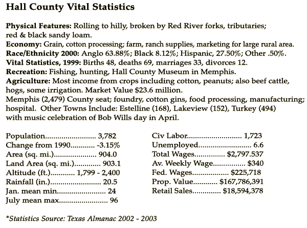
This old western style villa soon prospered - and it is now the second largest city here,
and is also home to Bob Wills Day, which is held every April as a way to honor
the famous King of Western Swing.
Beautiful Estelline was founded in 1892 by two brothers named
Wright, and a train station was established there. This made it very
important for shipping livestock and was soon hailed
for its great progress & prosperity. It had a well known supply house and
had its own banking system along with two newspapers.
It quickly grew to be over 1,000 just prior to 1910.
It was hard hit by the Great Depression and
a large fire which destroyed several important buildings around 1940.
Through all these troubles, Estelline still remains strong and is
one of the region's unique jewels which has stood the test of time.
In the early 1900's, the population was gaining at a rapid rate
due to the territory's attraction to the continuing influx of sojourners, and it grew even more rapidly as
the old homesteaders would continue to sell off their properties for large profits to the new occupants coming here.
These unique circumstances eventually led to the vicinity blossoming into an agricultural hub
which was strengthened by the planting of corn,
as well as by the increasing need for poultry production during the first decade of the century
which also proved to be an important commercial foodsource.
The rich, loamy soils, when blessed with the necessary rain, regularly
produced bountiful crops, and has since earned our region the undisputed title of "Cotton Capitol of the Panhandle."
Memphis became a vital trading hub, and quickly developed into one of the more prosperous locations around these parts.
In 1910 there were 8,279 souls accounted for. Between then & 1930 there was
excellent growth as indicated by the following enumeration which totaled 11,137.
In 1930, there were 16,936 individuals living here.
During the early part of the century, the vicinity proved to be progressive and
modern, and this resulted in good economic and civic expansion. These positive changes served to
further strengthen the area as a major cotton producer and as an excellent habitat not only to raise food, but children as well.
This era of prosperity and growth was soon to suffer as the
stock market took a mighty blow in 1929 which resulted in the Great
Depression. Hard times soon were to follow as a result of this devastating
nightmare.
Hit tremendously hard, there was a subsequent rapid decrease in number of occupants
as a result of farmers leaving their land
because of devastating crop losses due to the Dust Bowl.
It was very hard for many inhabitants, and as it was so tremendously difficult
here during these years, the population began a steady decrease.
1940 listed 12,117 and from there the overall tally continued to drop
radically over a period of decades as shown in the subsequent ennumerations.
In 1950 this was dropped to 10,930 and there was an additional decline to 1960 where
the number was listed as being 7,322.
By 1980, the estimate was further reduced to 5,594,
and the most recent data from 2000 showed a decrease of -3% since
1990.
The boundaries enclose 904 sq. miles and according to statistics, that
equates to 4.2 residents per square mi., as compared to the much larger state average of
79.6. The area is not plagued with the burdens of
crowded living that has overtaken many communities in the south,
and the folks here have worked hard to retain its wonderful
rural charm.
This is truly a wonderful place to live and raise children. The
friendly atmosphere and kind citizens whom live here make it beyond a doubt
one of the finest locales in all of the lone star state!
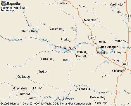
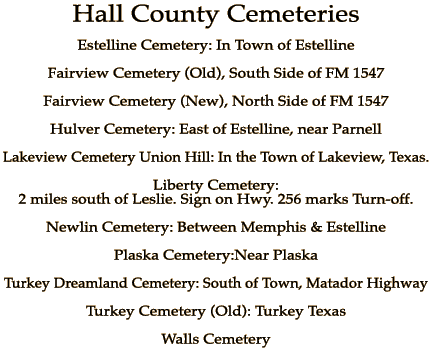
Old Towns Include:
Brice
Cone Springs (Ephraim)
Deep Lake 1 (Ephraim, Shoe-Bar)
Deep Lake 2 (Way)
Dothan
El (Elite, TwinButtes)
Elite (Eli)
Elmore (Felix)
Ephraim (ConeSprings, DeepLake l)
ESTELLINE
Felix (Elmore)
Gazelle)
Gipaw
Greasy Neck (Parnell)
Hulver (Nebo)
LAKEVIEW
Lesley
Locus (Plaska)
Lodge (Plaska)
Nebo (Hulver)
Newlin
Ostella (Turkey)
Parnell (GreasyNeck)
Plaska (Locus Lodge)
Pleasant Valley
Pope (Webster's)
Rothwell (Tell)
Settlement
Shoe-Bar (DeepLake 1)
South Brice
Tampico
Tell (Rothwell)
TURKEY Roost (Ostella)
Twin Buttes (Eli)
Way (Deep Lake 2)
WEATHERLY
Webster's (Pope)